|
I. SOIL FORMATION
Parent Material Before the glacial period, the topography of the state was rather rough
and rolling, similar to that now found in southern Indiana (Soil Regions
11, 12, and 13, Fig. 1), which was never covered by the ice. Glaciers,
ice sheets hundreds of miles long and hundreds to a few thousand feet
thick, covered most of the state during at least three different ice
ages. From the oldest to the youngest, these glacial ice ages have been
called the Kansan, the Illinoian, and the Wisconsinan Ages. Lacustrine (lake bed) materials were deposited from slowly
moving or ponded glacial meltwater. Because the coarser particles dropped
out of moving water as outwash, only the finer particles, such as fine
sand, silt, and clay, remained to settle out of still water. Soil Regions
1 and 2 contain many lacustrine areas. Those in northern Indiana were
deposited during the most recent glacial period (Wisconsinan). Many lacustrine
deposits in southern Indiana are older. Silt was carried by the wind a greater distance from the flood
plain and then settled out of the air as loess. Loess was blown
mainly from the Wabash and White River Valleys in central and southern
Indiana. Near the river valleys, in Soil Region 5, loess is thick, and
the soils formed in it are deep. The Hosmer soil (Plate 12), found in
Region 5, formed in more than five feet of loess. Farther away from these
valleys, loess is thinner but still is the parent material of the upper
part of the soil. For example, the upper horizons of most of the soils
in Regions 8, 9, and 10, and of some of the soils in Regions 11, 12,
and 13 are in loess. In several areas, weathered bedrock was covered with a layer of loess from a few inches to several feet in thickness. It is thicker near major rivers and becomes thinner away from the rivers. Loess is also thicker on nearly level uplands and thinner on sloping areas because it was eroded during and after the time of loess deposition. The variation in kinds of soils formed in these areas depends on the type of bedrock, the amount of loess that covers it, and the influence of other factors, such as relief and vegetation. The upper 18 inches of the Trappist soil (Plate 10) formed in loess. Alluvium, sediment recently deposited by water, is the parent
material of soil on flood plains. These materials are usually stratified
(arranged in layers) The Genesee soil (Plate 8) is markedly stratified
both in particle size and color. The black color is due to high organic
matter content. Many soils on flood plains do not show this much stratification.
Large areas of alluvial soils are on the flood plains along the major
rivers of Soil Region 3. Smaller areas of these alluvial soils are also
along streams in many other soil regions. A similar parent material is local
overwash. It was washed into closed depressions (bowl-shaped landforms)
from nearby higher areas, not carried in by a stream. Relief
Relief describes the shape of the land surface. It influences natural drainage,
movement of water in the landscape, erosion, plant cover, and soil temperature.
Relief is described by landform and slope gradient (%) in soil evaluation.
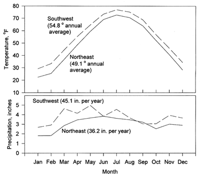
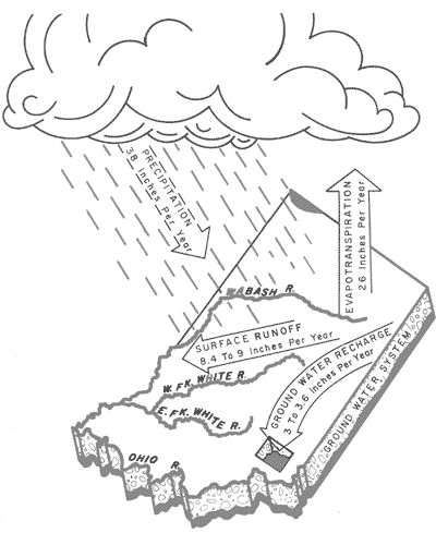
Natural soil drainage, erosion, and slope are also evaluated. The effect of natural drainage on soil development is evident in a comparison of soils that formed from similar parent material but under different drainage conditions. For example, the poorly drained Brookston soil (Plate 4) and the well drained Miami soil (Plate 2) both formed in loam-textured glacial till. Brookston soils are in depressions and have thick, dark surface layers and grayish subsoils with yellow brown spots or mottles. In contrast, Miami soils are on sloping areas and have yellowish brown colors in the upper part of the subsoil. Regions 1, 2, 3, 7, 8, and 9 are, for the most part, nearly level but also include some sloping areas. Region 10 has nearly level areas broken up by steep slopes or ravines along drainageways. Soil Region 11 (especially the eastern portion that includes Brown Co.) and Region 13 have a large proportion of steep slopes. Regions 4, 5, and 6 are more moderately sloping. In Region 12, soils overlie limestone bedrock. They are gently sloping and usually have many closed depressions, called sinkholes, that have no surface outlets. Water moves through the bottom of the sinkholes into underground caverns. Streams flow underground through these caverns. Water flows in surface streams only during storms. back to topClimate Climate is important in the formation of soils. It determines the kinds of plant and animal life on and in the soil. It also determines the amount of water available for weathering minerals and transporting the materials released. Through its influence on temperature, climate also determines the rate of chemical weathering in the soil. The temperature in Indiana fluctuates widely from summer to winter, typical of mid-continental regions (Fig. 2). It is almost 6°F lower in northeast Indiana than in southwest Indiana. Precipitation is greatest in spring months. Southwest Indiana tends to be wetter in the winter and spring than northeast Indiana. Central Indiana gets around 38 inches of rain each year (Fig. 3). About 26 inches is evaporated from the soil surface or transpired by plants growing in the soil. The rest moves off the soil as runoff or moves down through the soil to the ground water. During soil formation, many plant nutrients are leached (washed out) from the surface and subsoil horizons by water moving down through the soil. This means that most soils will require fertilization to achieve good crop yields.
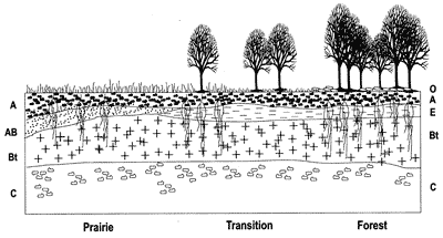
Fig 3. Average annual precipitation in Indiana and how it cycles. Many soil parent materials contained much ground up limestone when deposited, but this material has been dissolved and leached from the top several inches in the younger soils and from the top several feet in older soils. Consequently, many of our soils are now acid and need to be limed. back to topOrganisms Plants have been the principal organisms that influence soils in the state. However, bacteria, fungi, earthworms, and the activities of man have also been important. The chief contribution of plant and animal life is the addition of organic matter to the soil. Plant roots and earthworm tunnels also provide channels for movement of water through the soil. The distribution of organic matter in a soil depends on the kinds of plants that grew on that soil. Soil bacteria and fungi break down dead plant material. Some of it remains in the soil as humus, but some is broken down further to nutrients that can be used by plants. Soils are affected greatly by the type of vegetation under which they were formed. The native vegetation of Indiana consisted mainly of deciduous hardwood forests, prairie grasses, and water-tolerant grasses and sedges. Grasses have a large, fibrous root system which adds large amounts of organic matter throughout upper layers of soil each year. Thus, soils formed under grasses have a thick, dark-colored surface horizon. In contrast, in the forest, leaves fall on the soil surface and add organic matter on top of the mineral soil. This results in a thin, dark-colored surface layer of organic material over a lighter-colored layer (Fig. 4).
Fig 4. The relationship of soil horizons to native vegetation.
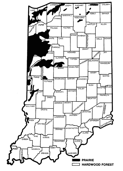
Fig 5. Locations of major areas of
soils formed under prairie The influence of native vegetation on soils is clearly illustrated in the color plates. The Miami soil (Plate 2) formed under forest vegetation and the Parr soil (Plate 5) formed under prairie vegetation, while the other soil-forming factors were similar for both soils. Fig. 5 shows the distribution of soils formed under forest vegetation and under prairie vegetation in Indiana. Fig. 1 also shows, by cross-hatching, the areas covered by prairie vegetation when European settlers first arrived. back to topTime It usually takes a long time, hundreds or thousands of years, for horizons to form in parent materials. The longer a soil surface has been exposed to soil forming agents like rain and growing plants, the greater the development of the soil. Some soils in Indiana are on young surfaces, less than a few thousand years old. Most of these surfaces were created when new material was deposited by water or by wind. Other young surfaces were created when upper soil layers were removed by erosion, such as on very steep slopes. Soils on young surfaces show very little horizon development. The Genesee soil (Plate 8) is an example of a young soil. It formed in recently-deposited material along creeks and rivers such as in Soil Region 3, and has indistinct soil horizons. The layering in Genesee is due to the nature of the materials deposited by water and not to soil horizon development. In much of the state (Soil Regions 1-9, except for part of Region 3), soil parent materials were left behind by glaciers about 15,000-20,000 years ago. Some of the material was deposited directly by ice, and other material was carried by the glacier and subsequently moved by water or wind. Soils on these surfaces have well-defined horizons for example, the Hosmer soil (Plate 12) and the Ockley soil (Plate 6). Much of south central and southeastern Indiana was not covered by glaciers 15,000 to 20,000 years ago. Part of this area was covered by older glaciers a few hundred thousand years ago, and part was never covered by glaciers so the soils may be a few hundreds of thousands years old. Some of these soils, however, were eroded a long time ago, and then covered with loess around 20,000 years ago. In Region 10, soils formed in glacial material several hundred thousand years ago. A few hundred thousand years ago the soils were partially eroded. Many of these soils were then covered with a few feet of loess about 20,000 years ago. In Regions 11, 12, and 13, loess was deposited on many soils formed in weathered rock, most of which never had been glaciated. The soils in these regions with no loess cap are the oldest soils in the state. back to top |