|
Agronomy Water Quality Research Facilities |
|||
|
FACILITIES Water
Quality Field Station (ACRE) Experimental Drainage Project (SEPAC) LINKS Environmental Sciences & Engineering Institute (ESEI) Center for Technology Transfer & Pollution Prevention
|
 |
||
|
|
 |
||
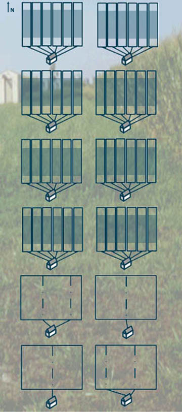 Inside the sheds... Inside collection huts for the drainage lysimeter plots, six tiles each flow over Purdue tipping bucket flow meters. The flow meters are connected to a datalogger which controls automatic samplers (ISCOs). When an appropriate amount of flow (or time, if desired) has occurred, the sample pump removes a sample from the tile and stores it. The volume of flow is recorded hourly, as are local rainfall from rain gauges and time of each sample collection. The data systems and automatic sample pumps have been very reliable and easy to maintain. They are powered solely by solar panels charging a 12-volt deep-cycle marine battery. Drainage Lysimeters... The WQFS includes 48 drainage lysimeter plots. The test plots are 10 meters by 48.5 meters (32 x 158 feet), large enough for a tractor with standard equipment. Each plot contains a drainage lysimeter, a clay box surrounding a tile-drained area of soil 24 meter long and 10 meter wide. The tile is perforated only within the clay box, and leads directly to a hut with collection equipment. The lysimeter plots allow measuring, monitoring, and subsurface water sampling as rainfall on the plot flows through the soil column. The volume of water and concentrations of transported chemicals can be determined for each plot as frequently as desired. Tile Spacing Plots... The drainage spacing experiment will facilitate scale-up of lysimeter data to match standard agricultural drainage practices. The plots are laid out on three standard tile spacings - 10, 20 and 30 meter widths (33, 66, 99 ft.). A colored plot map shows the layout of the tiles within the plots. 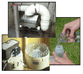  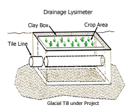   |
|
||
 |
The WQFS facility, developed on a gently sloping 10-acre site, consists of 54 individually tiled and instrumented plots. Forty-eight plots are constructed to be isolated drainage lysimeters. The remaining six plots are built on three standard tile spacings. | ||
|
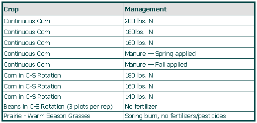
The 48 drainage lysimeter plots are divided up into 4 replications of the cropping systems listed. Click here for a more detailed listing and layout of the treatments and replications.
The tile spacing plots are planted under continuous corn with starter N and P and 160 pounds preplant N. Tillage operations consist of fall chisel-plow on corn plots and then spring disk and field cultivated. Soybean plots are spring disked and field cultivated. Herbicides are used to keep down the weeds during the growing season and no cultivation occurs after crops are put in the ground.
|
|||
|
Current Projects Carbon Storage Study Issue: The moisture content of soils has a significant impact on their ability to store carbon. Wetter, cooler soils tend to hold more carbon due to the fact that decomposition (and the rate at which CO2 is released) is slower, but drainage may also affect movement of carbon through the soil profile. A study is being conducted to look at how drainage can affect soil carbon levels. The WQFS allows the measurement of drainage rates under different cropping systems while taking soil carbon measurements and testing tile runoff for carbon. The findings will hopefully lead to greater understanding of the optimal drainage systems for carbon storage on typical soil/crops conditions in this region. Research: Impact: With the concern over ever-increasing CO2 and other GHG concentrations in the atmosphere, there is hope to help offset CO2 emissions with increasing the amount of carbon stored in the soil. Management practices that enhance our ability to increase soil carbon levels offer different results under various soil and climate conditions. This research may expand our understanding of how carbon levels are affected under typical drainage conditions of this region.
Past Projects Soil Hydraulic
Properties Issue: The main function of agricultural tile drains is to transport excess soil water from an agricultural field's subsurface soil to an outlet into surface water. When a field is tile-drained, rainwater moving through the soil will move much more rapidly to a watershed outlet when compared to water travel time in the natural soil matrix. Because the rate of water movement in a watershed directly impacts flood risk and risk of surface water contamination from sediments, nutrients and other agricultural chemicals, it is important to be able to predict the hydrograph (water flow volume as a function of time) produced by tile drains installed in different types of soil. Traditional forms of watershed models are only just beginning to take into account the effect of tile drainage. Research: The purpose of this project was to develop and test a simple analytical model for subsurface tile drain flow. Studies were conducted at the WQFS to characterize soil hydraulic properties. Green-Ampt theory was used to describe the infiltration and redistribution of rainfall in the vadose zone. Semi-analytical solutions were sought for the Bossinesq equation describing subsurface saturated flow subjected to time-dependent recharge. The model was applied to hourly measurements of tile drainage water volumes during rainfall events to test its ability to predict hydrographs. A simple one-term model was found to perform as well as a more complex model (Hydrus 2D) because of the large degree of spatial variability in soil hydraulic properties. Impact: These results demonstrated that, until a more accurate means to describe the spatial variation in soil hydraulic properties becomes available, simple models can be used to predict tile drainage flow. Predicting tile drainage flow volume is a critical component to assessing pollutant loading of surface waters in agricultural landscapes.
|
|||
| Last
update:
3/3/08
Comments or questions? Contact page designer. |
|||