Lakes and Wetlands parameterization for the NEESPI domain
Original lake and wetland algorithm
File Format
The parameter files for lakes and wetland specification in VIC have varied a bit during the development phase of the lake and wetland algorithm, such that there are small diferences between the format required for the model code used for Bowling and Lettenmaier (2010) and that specified in the current release version of VIC.Bowling and Lettenmaier (2010):
Line 1: [gridcell no.] [no. nodes] [min. depth for runoff] [width fraction] [starting depth] [contributing frac]
Line 2: [depth 1] [fractional area 1] ... [depth n] [fractional area n], where n = no. nodes and depth 1 = lake and wetland max. depth
VIC Release version 4.1.2:
Line 1: [gridcell no.] [lake_idx] [no. nodes] [min. depth for runoff] [width fraction] [starting depth] [contributing frac]
Line 2: [depth 1] [fractional area 1] ... [depth n] [fractional area n], where lake_idx is the index of the grid cell vegetation type from the vegetation parameter file that will be used as wetland vegetation when surface water is not at maximum extent (previously defaulted to zero in Bowling and Lettenmaier (2010)).
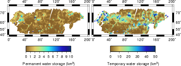
Both files describe lake model parameters that are fixed in time, but can vary in space by grid cell: the minimum depth for runoff out of the lake (zmin), the channel width fraction (f), the fraction of the surrounding vegetation types that drains to the lake and wetland tile (alpha) and the depth-fractional area curve, A(z). The depth-fractional area curve varies from the maximum depth of the combined lake and wetland area (Zmax) and the fraction of the grid cell covered by water at maximum extent (Amax) to 0.0, 0.0. (A bottom depth, area pair of 0.0, 0.0 is assumed by the model.) The number of nodes simply controls how many depth area pairs will be read in, it does not control the number of computational layers.Parameter Estimation
Parameter files for the NEESPI domain were created following the methodology used by Bowling and Lettenmaier (2010) which requires a landcover classification that includes both open water and wetland land classes, a digital elevation model (DEM) and available databases regarding lake depth distributions.The physical description of the pond and wetland extent, A(z), for each model grid cell consists of five components:
- The maximum lake and wetland extent (Amax) was set equal to the sum of the open water class and all wetland landcover classes in the Bartalev et al. (2003) land cover dataset. These classes included: Bogs and Marshes, Palsa Bogs, Riparian Vegetation, Sedge Tundra, and Salt Marshes.
- The minimum open water extent before surface runoff stops (Amin) is assumed to be the semi-permanent open water extent and is set equal to the extent of the "water body" class in Bartalev et al. (2003).
- The minimum depth for runoff (Zmin) is therefore also considered the maximum depth of permanent open water and is estimated from regional regressions of maximum lake area versus lake depth. Lake area and depth data came from Lake depth dataset, version 1.0 , developed by Ekatherina Kourzeneva, using a prototype data set of Natalia Schneider.
- The water depth associated with the seasonally flooded area (Zmax -Zmin ) is estimated from the average topographic slope (percent rise) of all wetland land areas within each grid cell. To calculate a wetland elevation change from the slope, the average width of the wetland area is estimated using the zonal thickness of the wetland land cover class (the radius of the largest circle which can be inscribed within each wetland zone).
- Below Amin, A(z) is assumed to follow a parabolic profile of the form A(z)=Amin(Z/Zmin)^1/2. A(z) is assumed to be linear between Amin and Amax.
- The contributing runoff fraction (alpha) is assumed equal to the fraction of the combined lakd and wetladn area (Amax), following Krinner (2003) and Mishra et al. (2010).
The channel width fraction (f) can take on values from 0.0 to 1.0 and 0.0 to 0.5, respectively. Future work may refine a methodology for specification of a priori spatial distributions of f and alpha.
Downloads
The lake and wetland parameter estimation described above was originally done using Arc/Info:Lakes and wetlands with subsurface moisture exchange
File Format
In order to allow subsurface water exchange between surface water bodies and their adjacent wetlands, the hydraulic gradient between the wetland and surface water is calculated using the TOPMODEL storage deficit approach and a drained to equilibrium soil moisture profile. This solution requires both the average generalized topographic index and the average topographic slope of the fractional area between node i and i+1.Bowling et al. (2010):
Line 1: [gridcell no.] [lake_idx] [no. nodes] [runoff depth] [width fraction] [starting depth] [contributing frac]
Line 2: [depth 1] [fractional area 1] [topoindex 1] [tanbeta 1] ... [depth n] [fractional area n] [topoindex n] [tanbeta n], where n = no. nodes and depth 1 = lake and wetland max. depth
Parameter Estimation
Subsurface exchange parameter files for the NEESPI domain were created following an adaptation of the above methodology. First, the bathymetry of wetland areas is derived using the distribution of the generalized topographic index for each grid cell:- The ACE2 dem in an EASE projection, disaggregated to 100.2701 m resolution was clipped to the boundaries of each 100 km grid cell.
- Grid cell DEMS were filled using the fill_flat_area.c program of Pelletier (2008).
- The generalized topographic index (a/tan B) was calculated for each grid cell dem using the multiple flow direction algorithm of Pelettier (2008).
- For each 100 m pixel, the average slope (B) and average elevation change between the current pixel and any adjacent pixels at lower elevation (deltaZ) are calculated.
- TI values from only those pixels falling into wetland land classes in the Bartalev et al. (2003) dataset are ranked from highest to lowest. The ranked list is broken into 14 classes (approximately equal area). The average TI, B and deltaZ and total area is calculated for each wetland class.
- Amin and Zmin are defined as described above. The lake bathymetry follows a parabolic profile.
- Wetland bathymetry is determined by the 14 wetland classes. Let w represent the node ID of the first wetland class in the parameter file (such that lake bathymetry is described by nodes 1 through w-1).
- depth [w] = depth [w-1] + deltaz [w]
- fractional area [w] = fractional area [w-1] + area [w]
Downloads
Click on the images below to download new style lake parameter files for the NEESPI domain.