
NASA Surface water products in RFC Forecasts
- Status: Funded by the NASA Terrestrial Hydrology Program
- Duration: October 2014 to October 2017
- PI: Andy Wood, NCAR
- Co-PIs and Collaborators:
- Laura Bowling (AGRY, Purdue) and Keith Cherkauer (ABE, Purdue)
- Yuquiong Liu (NASA; UMD) and Christa Peters-Lidard (NASA)
- Pedro Restrepo (North Central River Forecasting Center)
- Graduate Students: Charlotte Lee (ESE, Purdue)
Project Summary:
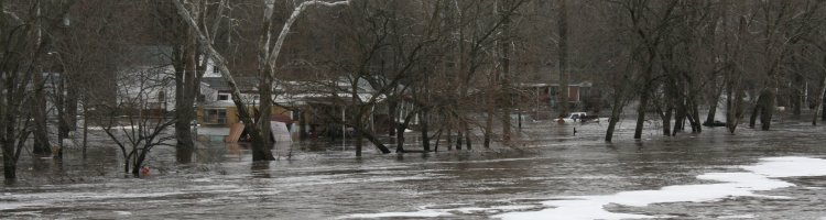
River flow forecasting on the high plains of the US upper midwest presents a number of challenges, including a relatively low density of in-situ hydrometeorological observations and decades-long practices of landscape modification. Both factors contribute to large uncertainties in quantifying the components and fluxes of the hydrologic cycle over time spans of days to decades. Current and prior operational efforts to predict flood crests on the Red River have at times contributed to large and ultimately costly errors. Indeed, the most recent flood predictions by the National Weather Service (NWS) North Central (NC) River Forecast Center (RFC) on the Red River in the spring of 2013 were significantly overforecasted, leading to unnecessary investments of millions of dollars in hazard mitigation. Considerable volumes of water were observed to pond behind county road embankments and on fields (Figure 1), and only about 30% of the predicted runoff from the seasonal peak snow water equivalent made it to the river during the spring runoff. The central applied science question addressed by this proposal to the NASA Terrestrial Hydrology Program is whether retrievals depicting inundated land area can provide usable information to improve the quality of hydrologic simulation and prediction, hence water management during events such as floods. To this end, the proposed effort has two major objectives:
- Develop and use remote sensing imagery of water inundation to augment retrospective distributed hydrologic modeling analyses to improve our understanding of the region’s large-scale runoff response to rainfall and snowmelt events coupled with terrain and subsurface influences at the field scale.
- Investigate the potential of current data assimiliation approaches to leverage remote sensing so as to reduce hydrologic simulation and prediction errors associated with the spring snowmelt period.
The objectives of the project will be achieved though four major components. First, the Variable Infiltration Capacity (VIC) hydrology model will be calibrated over this region, including the wetlands algorithm that will be used to account for surface water detention. Second, remote sensing imagery will be used to develop gridded time-series analysis of inundated land areas in the study domain (the region in which NCRFC forecasts). Third, automated data assimilation approaches will be employed to update the VIC simulations using the inundated land areas and/or estimates of ponded water volume, in a retrospective assessment. And fourth, standing surface water analysis products suitable for use in NCRFC forecasting operations involving the Snow17 and Sacramento model pairing will be developed in coordination with the NCRFC personnel, and evaluated within the NCRFC modeling system. Purdue University Co-Is Laura Bowling and Keith Cherkauer are the principle developers of the VIC model functionality related to cold land processes (e.g. frozen soils and temporary surface water detention). They have also done extensive modeling in the agricultural areas of the upper Midwest, which includes the project’s study domain in the North Central River Forecast Center. Their roles in the project will be to adapt existing implementations of the VIC model to project purposes, to share the model implementation and to train the project team on this implementation of the VIC model. They will also help NCAR and NASA to integrate the VIC model with lake/wetland algorithm functionality into NASA’s Land Information System (LIS), which still uses a prior version of VIC.