
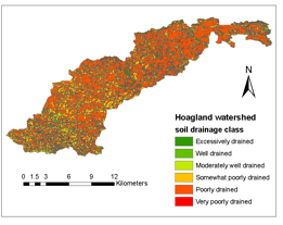
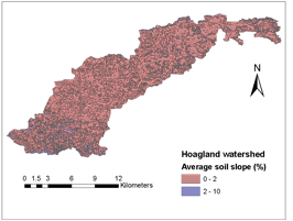
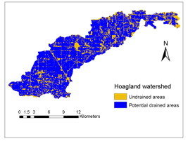
Potentially Drained Area in Hoagland Watershed
Our mapping of the agricultural land area in Indiana which is likely to have subsurface drainage improvements began with the Hoagland Watershed in west central Indiana. This potentially drained area was mapped from the National Agricultural Statistic Service (NASS) land cover dataset, as well as soil drainage class and soil slope data from the Natural Resource Conservation Service (NRCS) SSURGO database using the decision tree classifier model developed by Naz and Bowling (2009). The decision tree classifies all the crop land that is some what poorly/poorly/very poorly drained and has an average soil slope of less than 2% as potential tile drained area.
Click on the images below to download Google Earth-compatible layers (*.kml files) for Hoagland watershed.
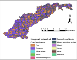
| 1 | Corn |
| 5 | Soybeans |
| 24 | Winter Wheat |
| 26 | Winter Wheat/Soybeans Double Cropped |
| 36 | Alfalfa |
| 61 | Fallow/Idle Cropland |
| 62 | Pasture/Range/CRP/Non Ag (Permanent & Cropland Pasture, Waste & Farmstead) |
| 63 | Woods, Woodland Pasture |
| 81 | Clouds |
| 82 | Urban |
| 83 | Water |
| 87 | Wetlands |