II. SOIL AND LANDSCAPE PROPERTIES
Parent Materials
Parent material is the geologic material from which soil horizons form. Many soils have more than one parent material, for example loess over till. Chapter I discussed parent materials, along with the four other soil forming factors. The first chapter also described soil horizons, such as A, E, B, C, and R. You will need to be familiar with this information to understand the following discussion. Soil texture and Munsell color names are used to describe parent materials. If you are not familiar with these names, read the Texture and Color sections later in the chapter and then return to this section. Sometimes, properties of a parent material do not completely match the guidelines for any parent material. In that case, one should choose the one that matches best.
Subsections:Parent Material Zone | Alteration of Parent Materials to Form B Horizons |
Kind of Rocks |
Kind of Parent Materials
Parent Material Zone
Every soil horizon has a parent material, but the same parent material usually appears different in different horizons because soil formation processes have altered it. In C horizons, parent materials are relatively unchanged from when they were deposited, but they have been altered by soil forming processes to form A, E, and B horizons. The descriptions that follow are for parent materials that have been little changed by soil formation processes. In soil evaluation, the depth at which to determine parent material is written on the site card. Often this parent material zone is in C or BC horizons because this parent material best matches the following descriptions and is most related to landforms. In many cases, however, the parent material zone will be in horizons in which the parent material has been altered, such as B horizons, because unaltered parent materials are not exposed in the pit or because of some other reason specific to the site. Therefore, it is important to know how parent materials are changed during soil formation.
back to topAlteration of Parent Materials to Form B Horizons
The following changes that affect the appearance of soil horizons may take place as parent materials are altered to form B horizons:
- Carbonate minerals are dissolved (the material is no longer calcareous).
- Clay moves down from the A and E horizons into the B horizon. Some of the transported clay forms clay films on peds.
- Iron oxides move downward into the B horizon. In well-drained soils, these horizons are reddish or brownish.
- Blocky structure forms.
- The material may become brittle (in fragipan horizons).
Several of these changes are illustrated in Table 2. The column labeled “C or BC horizon” lists some properties of soil materials that were changed very little during soil formation. If the soil pit is deep enough to expose the C or BC horizons, these horizons will be used as the parent material zone. The column labeled “B horizons” lists properties of B horizons to show how parent material was altered during soil formation. The designated parent material zone may be in B horizons, especially in southern Indiana, where soils are deep and C and BC horizons are not exposed in soil evaluation pits. The change in properties from column three to column four illustrates the processes identified by bullets in the previous paragraph. The paragraphs below explain the changes shown in Table 2.
The Gilpin soil, formed from weathered bedrock, contains many channers (flat pieces of bedrock) in both C and B horizons, but more in the C. The B horizon has redder color and stronger blocky structure than the C.
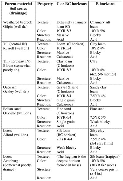
Table 2. Properties of C or BC horizons and B horizons formed in the same parent material.
In general, till contains more sand than loess but less sand than outwash. Usually till also contains some pebbles that are absent in loess. Relative to till C horizons, till B horizons contain more clay, are redder (in well drained soils), have blocky structure, and lack carbonates.
Outwash contains much sand and often some gravel, but very little silt and clay. Relative to outwash C horizons, outwash B horizons contain much more clay, are redder, have blocky structure, and lack carbonates. Compared with till B horizons, outwash B horizons are usually sandier and redder. Outwash was stratified (deposited in layers) when it washed out of the glacier.
Eolian sand has a distinctive particle size (mainly fine and medium sand). Usually B horizons are redder than C horizons.
Loess contains very little sand in C or B horizons and essentially no pebbles. Many southern Indiana soils will have no BC or C horizon exposed in pits, as shown by the Avonburg soil in Table 2.
Parent materials are closely related to landforms, as explained in the Landform section. Knowing the kind of parent material, therefore, will help you identify the landform, and recognizing landforms will help you identify parent materials. Identifying parent materials will also help you identify limiting layers. Parent materials and guidelines to identify them are presented below in the general order of when they were deposited. If the material in the parent material zone does not meet any of these guidelines, official judges should give the name of the parent material on the site card.
Official judges will list on the site card the depth of the parent material zone, in which parent material is to be judged. Often it is in BC or C horizons, because that parent material relates best to landform, but it may be anywhere in the subsoil. The descriptions of parent material below refer mainly to BC and C horizons. The relation of B horizons to BC and C horizons is described in Table 2 and the associated text.
Official judges are encouraged to list the parent material on the
site card if it does not clearly meet the alterations described above
or the descriptions given below.
back to top
Kinds of Rocks
Rocks are made up of one or more minerals, such as quartz. Bedrock is solid rock material that can be exposed at the earth’s surface or that underlies loose material, such as loess, till, or outwash. This section discusses the main kinds of rocks from which soil parent materials were derived. Rocks are classified into three types according to their origin.
Igneous rocks formed deep in the earth when molten rock material cooled and became solid. Igneous rocks are composed of a variety of minerals of various colors giving them a speckled appearance. Many tombstones are made from granite, one kind of igneous rock that contains pink, white, and some black minerals.
Sedimentary rocks formed at the Earth’s surface when fragments of other rocks settled out in shallow seas and were cemented together, or when materials were produced by organisms. Sandstone consists mainly of sand particles, which are large enough to be visible. Weathered sandstone has a scratchy feel. Siltstone consists of accumulations of silt-size particles, which are too small to see. As siltstone softens and weathers, it acquires a soapy feel. Shale consists of even smaller, clay-size particles and generally has a distinctive platy appearance. It weathers to a material that feels sticky and plastic, like modeling clay. Limestone is another kind of sedimentary rock. Unlike the other sedimentary rocks, limestone formed mainly from shells of small marine animals that settled to the bottom of the sea. Limestone sometimes looks like sandstone because the shells are often about the size of sand particles. Limestone, however, consists mainly of calcium carbonate (lime) minerals, which fizz when diluted hydrochloric acid is dripped on it.
Metamorphic rocks formed when igneous or sedimentary rocks were buried and subjected to high heat and great pressure deep within the Earth. Common metamorphic rocks can look like igneous rocks, except that some have banded colors and others have a foliated (scaly) appearance.
All the bedrock under Indiana consists of sedimentary rocks, either sandstone, siltstone, shale, or limestone. When exposed in a road cut, sandstone, siltstone, and shale show horizontal layering or bedding because the rocks were deposited in layers. Limestone has a more massive appearance. Often water that percolated down through cracks in the rock dissolved out vertical channels that were later filled with red soil material. Some limestone has chert fragments, a whitish, irregularly shaped rock fragment.
Bedrock fragments usually have sharp edges and corners because they were not transported long distances and worn down. Pebbles in till, on the other hand, are quite well rounded. Thousands of years ago the glaciers picked up igneous and sedimentary rock that was near the earth’s surface in Canada. As the glaciers advanced into Indiana, they ground the Canadian bedrock into smaller pieces, rounding off the edges. When the glaciers melted, the rounded pebbles were left behind in till.
Rounded pebbles are also found in outwash, but because they were transported by water in addition to being ground by the glacier, they may be even more rounded than pebbles in till.
back to topKinds of Parent Materials
Weathered Bedrock
When bedrock is broken down by physical and chemical processes it is transformed into weathered bedrock. All parent materials have been weathered from bedrock at some time, but here the term weathered bedrock refers to materials that have stayed essentially in place (residuum) or moved downslope and collected at the base of a slope (colluvium). Weathered bedrock usually contains fragments of sandstone, siltstone, shale, limestone, or chert. These fragments usually are flat and/or have sharp edges and corners. In contrast, other parent materials such as till and outwash were transported greater distances and the pebbles in them are more rounded. Also, many of the pebbles in till and outwash are from igneous rocks instead of sedimentary rocks. The texture of weathered bedrock varies widely, depending on the size of particles in the original rock. The parent material zone may contain both weathered bedrock and bedrock that qualifies as a limiting layer.
Characteristics of weathered bedrock (including bedrock):
- More than 80% of the material in the diagnostic zone is so hard that roots will not grow into it (qualifies as bedrock limiting layer), or
- Less material is that hard, and:
a. Texture varies greatly depending on kind of rock, and
b. Sedimentary rock fragments, if present, are mainly angular or flat or both.
Siltstone, shale, and sandstone bedrock is common in Soil Region 11 (Fig. 1). Limestone, often containing chert, underlies Soil Region 12. Stratified shale and limestone are common in Region 13. Some characteristics of weathered bedrock are illustrated in the color plates. In Plate 9, the white material below three feet (numbers on the right side of the gray tape) is continuous limestone bedrock. If official soil judges listed 2 to 4 feet as the parent material zone, bedrock would be included in the zone according to the guideline. In Plate 10, soft shale was cut with the spade in the BC horizon, around 30 to 34 inches deep, as shown by the horizontal bedding. Harder shale (R horizon) is barely visible at the bottom of the photo.
Till
Till was deposited directly by glacier ice. This ice, up to a few thousand feet thick, ground up the bedrock below it, transported the ground material, and deposited it mainly in the central and northern parts of the state. Till was derived mostly from nearby bedrock, but some came from more distant sources. For example, the igneous pebbles and boulders (granite, etc.) in the till must have come mainly from Canada because all of Indiana is underlain by sedimentary rocks. Glacial pebbles are more rounded than the rock fragments in weathered bedrock because they were worn down while being pushed along under and in the ice. Till consists of a mixture of clay, silt, sand, and usually coarser fragments. In Indiana, all till was calcareous, and much of it was very dense when it was deposited.
Most tills have medium (loam) or moderately clayey (clay loam or silty clay loam) textures. Till usually has a distinctive yellowish brown color. Often loam till has a Munsell color of 10YR 5/4 or similar color (5/3, 5/6, 6/3). Clay loam and silty clay loam till may be somewhat more gray, 10YR 5/3 or similar color (5/4, 5/2).
The term calcareous means that the till contains carbonate (CO32-) minerals, such as CaCO3 (lime), and MgCO3, that were derived by grinding up limestone bedrock. Soil scientists identify the presence of carbonates in the field by dropping a small amount of dilute hydrochloric acid (10% HCl) on the sample. The acid reacts with carbonate, releasing carbon dioxide gas (CO2) which bubbles through the acid solution and appears to fizz. This reaction is called effervescence. Most of the glacial tills of the state contained around 20% to 40% of carbonate minerals when they were deposited. The carbonate minerals were dissolved during the formation of A and B horizons, and the products were leached out of the soil profile. Not all calcareous materials are till, however. Other materials, such as outwash, loess, or alluvium may also be calcareous. The upper depth to calcareous material is noted on the site card at each pit for soil evaluation.
The tills in Indiana were deposited by ice that was hundreds or even a few thousand feet thick. The weight of this ice on the till compressed or compacted the till below it to a very high density. Most till of Indiana has a density of 1.75 to 2.05 g/cm3, compared with 1.0 g/cm3 for water, 1.3 g/cm3 for a typical plow layer, and 2.6 g/cm3 for solid granite. Till with density more than 1.75 g/cm3 is called dense till and is considered to be a limiting layer for soil evaluation. In Indiana, most till is dense. In high-density soil horizons, most of the volume is occupied by solid particles and little is occupied by pore space. Since roots grow through soil pores, soil horizons with few pores also have few roots. Quite often dense till breaks apart into platy structure, with plates around 1/8 to 1/2 inch thick. This structure probably was formed when the till was deposited instead of through later soil forming processes. In such till the vertical cracks between plates are offset, like bricks in a wall, so that after a root grows downward through one vertical crack, it must grow laterally to find another vertical one. This greatly restricts root growth. Not all till is dense, however. If there is evidence that roots can grow into it, the till is not dense. In some soils, the uppermost several inches of calcareous material has blocky peds that are dense inside, but they are small enough that roots can penetrate into the horizon at intervals of a few inches apart. This material is not considered to be dense.
Downward in the soil, the peds get larger and larger, and the fractures between peds get farther and farther apart. Within the depth of a soil pit, these fractures may become coated with whitish carbonate minerals. The pattern of the whitish material surrounding browner soil appears much like a fragipan (Plate 16). The main difference, however, is that till is alkaline and calcareous and fragipans are acid.
Till is common in Soil Regions 6, 7, 8, 9, and 10 (Fig. 1). In Regions 6, 8, 9, and 10 most till-derived C horizons are medium (loam) texture. A few are moderately sandy (sandy loam borderline to loam). The upper horizons of many soils in these regions formed in loess, however. In Region 9, loess is between 20 and 40 inches thick, and in Regions 6 and 8 it is less than 20 inches thick. Soil B horizons that formed in loam till are mainly clay loam and those that formed in loess are mainly silty clay loam. Both are moderately clayey for soil evaluation. Dense till C horizons are shown in (Plates 2, 3, and 5)
In Soil Region 7, the till in C horizons is usually moderately clayey
texture (silty clay loam or clay loam), finer than in Regions 6 and 8.
Soil B horizons formed in this till are usually clayey (clay or silty
clay), but near the low-clay boundary of those textures. Within that
region, both the C and B horizons are highest in clay content in Allen
County, and the clay content decreases to the north, west, and south.
In Region 10, soil horizons formed in older till were buried by deep loess deposits, and on nearly level areas, the loess is thicker than four feet, the
depth of many soil evaluation pits. On steeper slopes of Region 10, however,
the loess is often thinner and till-derived horizons may be exposed in pits.
The texture relations there are similar to those in Regions 8 and 9.
Characteristics of till:
- Calcareous in C horizons.
- Pebbles, if present, are mainly igneous and are mainly rounded.
- Not stratified (layered).
- Usually has platy depositional structure in C horizons.
- Common texture and color combinations in C horizons:
a. medium texture (loam) and brownish color (10YR 5/4, 5/6,
5/3), or<br />
b. moderately clayey texture (clay loam, silty clay loam) and near
the brownish/gray boundary (10YR 5/3, 5/4, 5/2).
Outwash and lacustrine deposits
When the ice that deposited till melted, the meltwater carried away much gravel, sand, silt, and clay. The meltwater flowed very rapidly as it left the glacier, but then the streams spread out and slowed down, allowing the sand and gravel to settle out as material called outwash. This outwash contains very little silt and clay and generally is stratified, but in some materials, especially coarse sand and gravel, the layers are so thick that only one may be visible in a soil pit.
In some places, meltwater streams flowed into lakes. In the still water of the lake, the fine material such as silt and clay gradually settled out. Streams that flowed into lakes, however, also carried coarser material (sand) that immediately settled out. Thus, the lake or lacustrine deposits contain much silt and clay, but may also contain sand near the edges. Outwash and lacustrine deposits grade into each other and are not separated in soil evaluation.
According to soil evaluation guidelines, all outwash and lacustrine parent materials must be stratified except material that qualifies as a coarse sand and gravel limiting layer. “Stratified” means that material in the parent material zone consists of layers that are clearly visible, or are in different texture groups, or are both visible and in different texture groups. For example, alternating layers of sand (sandy texture group) and sandy loam (moderately sandy texture group) qualify as stratified, but alternating layers of loam and silt loam (both medium texture group) do not qualify if the stratification is not clearly visible.
Alluvium may also be stratified, but soil horizons in outwash have more soil development than those in alluvium. Soil development is shown by:
- More prominent color differentiation in the profile, for example, dark A horizon, pale E horizon, and brownish or reddish B horizon.
- Better development of soil structure, for example, blocky peds in the subsoil (B horizon).
- Evidence of downward clay migration—more clay in the subsoil (Bt horizon) than near the surface (A and E horizons).
- Presence of clay films on the outside of peds. Clay films are usually darker than the inside of peds and coat the peds like a thick coat of paint. The “paint” may cover up sand grains within the ped.
Characteristics of outwash and lacustrine deposits:
1. Pebbles, if present, are mainly rounded.
2. Material is either:
a. in the sandy texture group and the sands are mainly >0.5 mm in diameter
(qualifies as a coarse sand and gravel limiting layer if it is thick enough), or
b. in any texture group and is stratified (consists of layers that are clearly visible and/or are in different texture groups).
3. Strong soil development in the subsoil
(to distinguish it from alluvium and local overwash).
If official judges determine that the parent material is outwash
or lacustrine material, but it does not show clear stratification
or the material is not coarse sand and gravel, they will give the
parent material on the site card.
Large areas of outwash are on terraces and outwash plains of Soil Region 3 (Fig. 1), but smaller outwash areas are scattered among many other regions. Region 2 contains mostly lacustrine deposits on lake plains. Region 1 has extensive low-lying sand plains that some people call outwash and others call lacustrine deposits.
The Ockley soil (Plate 6) formed in outwash. The C horizon consists of sand and gravel, but no stratification is evident (2a above). The tongues of dark material (Bt3) that penetrate down into the C horizon (light material) are common in outwash soils. Rounded pebbles are shown in the Bt3 and C horizons.
Eolian sand
When glaciers melted, great floods covered the ancient floodplains that are now terraces, but when melting slowed down in the winter, these plains were barren mud flats. Wind blowing over the barren flats picked up some particles and carried them away. The coarsest materials, coarse sand and gravel, mainly stayed in place. The middle-sized materials, fine and medium sand, moved by skips and jumps. Eventually this process accumulated piles of wind-transported eolian sand into hills called dunes. Fine and medium sands are 0.1 to 0.5 mm in diameter. They can be identified by comparing the sand from a soil pit with two grits (sizes of sand particles) of sandpaper.
Some soils in eolian sand have lamellae, thin layers that contain somewhat more clay than the material above or below them (Plate 7). Eolian sand deposits are common in Soil Regions 1 and 4 (Fig. 1), with smaller areas scattered around the state. The Chelsea soil (Plate 7) formed in eolian sand. The reddish-brown bands in the subsoil constitute the Bt part of the E and Bt horizon, and are called lamellae.
Characteristics of eolian sand:
1. Sandy texture with no gravel or pebbles.
2. Sand grains are mainly 0.1 to 0.5 mm in diameter (between 150-grit
and 40-grit sandpaper).
3. Not stratified, but may have lamellae.
Loess
Silt-size grains were picked up by the wind blowing over barren flats of terraces and outwash plains. Silt particles are smaller than sand, so they were lifted higher in the air than eolian sand, carried further, and deposited as loess. Loess deposits are very thick in Soil Region 5 (Fig. 1). There, most soils formed entirely in loess. Some C horizons are calcareous, but most are not. In Region 10, loess is almost as thick, especially on nearly level areas, and it covers soils formed from older till. In Soil Regions 8 and 9, loess overlies till, and soils formed in both parent materials. Loess covers soils formed from bedrock in Regions 11, 12, and 13, and it covers soils formed from outwash and lacustrine deposits in areas too small to show on the Soil Region Map.
Since loess settled out from the air and was never under the weight of glacier ice, it was not compacted and is not dense. Soil B horizons (including fragipans) are silty clay loam or heavy (high-clay) silt loam. Loess-derived silt loam A horizons are very common in many areas of Indiana.
In summary, loess is the only parent material in a few soils and is the uppermost parent material of many soils in Indiana. It is not stratified. It commonly forms silt loam A horizons, silty clay loam or heavy silt loam B horizons, and silt or silt loam C horizons.
The Alford soil (Plate 11) and the upper 5 feet of the Hosmer soil (Plate 12) formed in loess. Loess can be identified better by estimating texture by feel than by looking at the photos.
Characteristics of loess:
1. May or may not be calcareous.
2. No or very few pebbles.
3. Silt loam or silt texture in lower part of profile (BC or C horizon).
4. Not stratified (in contrast to water-deposited material).
5. Not dense (in contrast to most till).
Alluvium
Alluvium is material that was recently deposited by a stream on its floodplain. The texture of alluvium varies greatly and is related to the kind of material eroded upstream from the floodplain. Alluvium often contains more organic matter than other parent materials, so alluvium can often be recognized by dark zones or alternating darker and lighter bands in the profile. Since the deposit is young, soils formed from it have weak development, recognized by poor horizon differentiation, weak structure, and lack of clay films. Soils formed in alluvium are mainly along the major streams of Soil Region 3 (Fig. 1), and also along smaller streams and drainageways in many other Regions. The Genesee soil (Plate 8) formed in alluvium. The photo illustrates both points of the guideline.
Characteristics of alluvium:
1. Two or more distinct layers that differ in texture and/or
organic matter content (color).
2. Soil horizons in and above the parent material zone have very weak
development.
Local overwash
Local overwash is similar to alluvium, except that overwash is soil material that was eroded from nearby hillslopes or swells and deposited on top of soils lower in the landscape. Overwash is usually found in depressions on uplands and terraces, but never on floodplains. Usually overwash was eroded from lighter colored soil horizons and overlies darker colored horizons. If overwash buries a light colored horizon, it may be difficult to distinguish the buried layer. If this is the case, official judges should give the parent material on the site card. If the overwash is 20 inches or more thick, the landform is called a filled depression in soil evaluation. Small areas of local overwash may be in almost any soil region.
Characteristics of local overwash:
1. More than 20 inches thick (but the parent material zone may
not include all 20 inches).
2. Buries a dark horizon.
3. Soil horizons in and above the parent material zone have very weak
development.
Other parent materials
If the material in the parent material zone does not fit any of the guidelines above, official judges will list the name of the parent material on the site card.
back to top