II. SOIL AND LANDSCAPE PROPERTIES
Landforms and Their Components
Landforms are the features of the earth that together make up the land surface. They may be large features such as a river terrace or floodplain, or small features such as a dune. Groups of landforms are called landscapes. Landforms are recognized by their shape or “lay of the land,” by their position relative to other landforms, and by the kind of material under the landform. Many soils of Indiana formed from two or more parent materials. Usually it is the lower parent material that is most related to the landform. For example, many soils formed in loess over till. Till is mainly responsible for the shape of the land surface, and loess merely drapes over the till. This is why the parent materials zone is usually deep in the pit. Landforms are important in understanding the relation of one soil to its neighbors.
Subsections: Landform | Landform components | Soil evaluation rules for landforms and their components
Three major landforms, upland, terrace, and floodplain, form a stair-step pattern in many landscapes (Fig. 10) and are extensive in Indiana. Dunes and filled depressions are less extensive landforms.
Uplands
Uplands are the highest parts of the landscape. They lie above the lowlands that are associated with rivers and streams. Uplands are underlain mostly by unstratified materials (without layers of contrasting particle-size), such as weathered bedrock, till, or loess. In the glaciated part of the state, Soil Regions 6, 7, and 8, the nearly level areas are called till plains and the areas with irregular hills are called moraines.
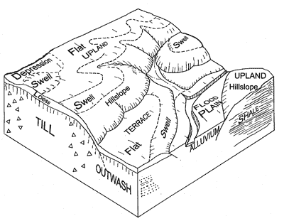
Fig 10. Block diagram showing some parent materials such as TILL (uppercase letters in cut faces of diagram), landforms such as UPLAND (uppercase letters on surface), and landform components such as Swell (Upper and lower case letters on surface).
Terraces
Terraces are at intermediate levels in the landscape, between uplands and floodplains, and associated with a river or stream. Most terraces are on outwash that was deposited by running water thousands of years ago. Terraces usually have a nearly level top surface (like the tread of the stair) and a short slope leading downward from that surface (like the riser of the stair). Landforms on other water-deposited parent materials are included with terraces for soil evaluation. They include outwash plains (landforms on outwash not in a valley), eskers (long ridges of outwash), kames (cone-shaped hills of outwash) and lake plains (landforms in former lakes underlain by relatively fine-textured material). For soil evaluation purposes, their parent material is outwash or lacustrine deposit, and the landform is called Outwash landform(s) for soil evaluation.
Most soils that formed in outwash on slopes of 3% or more are well drained, as illustrated by the Ockley soil (Plate 6). In outwash-derived soils on nearly level slopes (0 to 2%), natural drainage varies greatly. Soils in depressions are usually poorly drained. Soils on swells vary greatly in natural drainage, depending on depth to water table and on soil permeability. Soils on lake plains are usually finer-textured than outwash soils and tend to be more poorly drained.
Dunes
Dunes are hilly deposits of eolian sand with no obvious stratification. They are usually on or near terraces. The Chelsea soil (Plate 7) formed in eolian sand of a dune. The E and Bt horizons in Chelsea are soil horizons called lamellae, not stratified parent material.
Sandy deposits that meet the definition of eolian sand on nearly level terraces and outwash plains were initially deposited by water and then re-worked by wind. They are included with outwash landforms for soil evaluation.
Floodplains
Floodplains are the lowest part of the landscape near rivers and streams and are subject to flooding. Most are nearly level. Floodplains are made up of alluvium. Alluvium is often stratified and may be similar in texture to outwash and lacustrine deposits. Because the floodplains are much younger landforms, however, soils on them have much less development than those on terraces, outwash plains, and lake plains. The natural levee (flood plain swell, Fig. 10) is an area near the stream channel that is somewhat higher than the rest of the floodplain. This is where the stream first deposits its load during a flood. Usually soils on natural levees are well drained. Although a floodplain is usually near a stream, one may not be able to see the stream from the soil evaluation site. Look for evidence of flooding such as debris arranged in curved rows in a field, debris caught on fences or plants, water marks on trees, or surface deposits of new sediment.
The natural drainage of soils on floodplains depends on soil permeability, elevation relative to the stream channel, and depth to the water table. The Genesee soil (Plate 8) is well drained.
For crop production, flooding before or after the growing season may cause some problems but does not prevent farming altogether. If a late spring flood occurs, a farmer may delay planting or may replant using a shorter season crop such as soybeans or sorghum. Flooding that occurs any time of the year causes obvious problems for home sites. Houses should not be built on floodplains.
Filled depressions
Some depressions on upland or outwash landforms have been partially filled with sediment washed in from nearby higher landforms. Soils formed in this local overwash material usually have weaker structure, lighter color, and less clay than the underlying buried soil. If the local overwash is 20 or more inches thick, the site is called a filled depression. If the overwash material is less than 20 inches thick, the site should be called an upland depression or an outwash depression.
back to topLandform Components
Uplands and terraces are subdivided into landform components based on their gradient and shape of the slope. The slope break between 2% and 3% is important in naming landform components in soil evaluation. Slopes with gradients of 3% and steeper are called hillslopes; those with gradients of 2% or less are called swells, flats, or depressions, depending on their shape when looking at them from the side.
Nearly level landform components
If the slope is 2% or less, a distinction is made between convex and concave landforms. Convex forms are the shape of a ball and are called swells. Concave forms are the shape of a bowl or a channel and are called depressions or swales, as shown in the landscape diagram (Fig. 10). Depressions can be closed or open. A closed depression is bowl-shaped and has no outlet. Water that flows into it must either soak into the soil or evaporate. Water moves through an open depression, which is shaped like a channel or drainageway. For soil evaluation, flat land areas are included with depressions.
In actual soil landscapes, however, the shape of the land surface may not be distinctly convex or concave, so some additional clues may be needed to make the call. First, look around and decide in which direction water will move during a hard rain. Imagine that you are at the center of a clock and look at all the numbers on the perimeter. If water runs away from the soil pit in more directions (numbers on the clock dial) than it runs toward the pit, the slope shape is convex. If water tends to flow inward toward the pit from more directions, it is concave. An open depression or drainageway is shaped like a large pipe that is cut in half the long way to form a trough that is placed on a slight slope. At a point in the trough, water moves down the long direction and down from the sides, so water is moving into that point from more directions than it is moving away.
Landform components are judged independently of natural drainage, but the natural drainage of the soil often provides clues about the landform. In many nearly level swell-and-depression landscapes, water moves into depressions which makes the soils wetter, or poorly drained. On the other hand, water moves away from swells, making the soils somewhat poorly drained. This relationship does not always apply, however, because the soils in some depressions are somewhat poorly drained. In other cases, nearly level soils are very permeable and are well or moderately well drained. Flat areas are included with depressions because in many areas, soils on large flats are poorly drained. Examples of poorly drained flat areas include the large silty flats of southern Indiana with Clermont or Cobbsfork soils and flat lake plains with fine-textured, poorly drained soils, such as Zipp and Hoytville.
As much as possible, official judges will place slope stakes across areas to show the concave or convex nature of the land surface. If the surface rises between the stakes, judge the landform to be a swell. If the surfaces dips between the stakes, it is a depression. If the shape of the slope is still not apparent, official judges may write “Concave surface” or “Convex surface” on the site card.
Much of the nearly level glaciated upland of northern and central Indiana has swell-and-depression topography and the landscape is called a till plain. This landscape consists of swells on the convex rises and depressions on the concave lower areas of the landscape. In the forested part of the state (Fig. 5), soils on swells have light-colored surfaces and soils in depressions have dark-colored surfaces. The overall “salt and pepper” landscape is gently undulating with less than 2% slope between the high points of the swells and the low points of the depressions.
Upland swells usually have somewhat poorly drained soils, such as Crosby (Plate 3). In the upland swell position on sandy materials, however, the soils may be better drained. Upland depressions usually have poorly drained soils such as Brookston (Plate 4). Swell-and-depression topography is common in soil Regions 6, 7, 8, and 9 (Fig. 1).
Plate 1 illustrates swell-and-depression topography in Shelby County. The lightest areas are swells with Crosby soils, and the darkest areas are depressions with Brookston soils. The brownish or reddish spots to the right are Miami soils (Plate 2) on gentle slopes that have been eroded.
The salt-and-pepper landscape in Plate 1 also helps explain why the Ap horizon of Brookston (Plate 4) is not as dark as the unplowed A horizon below it. Erosion has removed gray and brownish material from the swells (Crosby) and hillslopes (Miami) and deposited it on the Brookston surface. Each year, as the soil is plowed, this transported material is mixed with the original Brookston surface, causing it to become lighter in color. Another reason for the lighter surface is that the organic matter is being decomposed because of drainage and cultivation.
In Soil Regions 5 and 10 in southern Indiana, the uplands have even less relief and lower slope percentages than the swell-and-depression topography farther north. Some of these uplands are so flat that it is difficult to determine if the surface is concave or convex. Flat upland landscapes (often called gray flats) usually have poorly drained soils such as Clermont, Cobbsfork, or Hoosierville. Near the edges of large flat areas, the slope tends to be convex and the soils, such as Avonburg or Vigo, are usually somewhat poorly drained.
Sloping landform components
Hillslopes are landform components with 3% or greater slopes. On 3% to 6% slopes, soils are usually well or moderately well drained. In some cases, small areas of somewhat poorly drained soils may be found on 3 to 6% slopes. All hillslopes have some degree of erosion hazard.
On slopes with more than 6% gradient, most soils are well drained. Typical soil series on these slope positions are Miami*, Parr, Chelsea, Caneyville, Trappist, Alford, and Hosmer soils (illustrated in Plates 2, 5, 7, 9, 10, 11, and 12). A few moderately well drained soils with fragipans and those with fine-textured subsoils may be on slopes greater than 6%.
* The Miami soil is listed in published soil surveys as well drained, but it is now considered to be moderately well drained.
back to topSoil Evaluation Rules for Landforms and Landform Components
Landforms for soil evaluation are defined on the basis of position in the landscape, parent materials, and the gradient and shape of the slope. The rules are summarized below.
The parent material, as judged previously, should be used to help determine the landform.
On nearly level landscapes, official judges, where possible, will place slope stakes across nearly level surfaces to show whether they are concave or convex in shape. If the shape is not apparent, they will write Convex surface or Concave surface on the site card.
Upland landforms:
1. Parent material is weathered bedrock, till, or loess.
2. Soil is strongly developed.
Upland hillslope—slope is 3% or more.
Upland swell—slope is 2% or less and surface
is convex.
Upland depression or flat—slope is 2%
or less and surface is concave or flat.
Outwash landforms (terraces, outwash plains, or lake plains):
1. Either
a. Parent material is outwash or lacustrine deposit, any slope, or,
b. Parent material is eolian sand and slope is 2% or less.
2. Soil is strongly developed.
Outwash landform, hillslope—slope is 3%
or more.
Outwash landform, swell—slope is 2% or
less and surface is convex.
Outwash landform, depression or flat—slope
is 2% or less and surface is concave or flat.
Dune:
1. Parent material is eolian sand.
2. Slope is 3% or more.
1. Parent material is alluvium.
2. Located near a stream.
3. Soil is weakly developed.
Filled depression:
1. Parent material is local overwash that is 20 inches or more
thick.
2. Most nearby landforms are uplands or outwash landforms (not floodplains).
3. Soil is weakly developed.
If the landform does not meet any of the guidelines above, official judges will write the name of the landform on the site card.